Ladawan:Nam-Viet 200bc.jpg
Pakadakula kan pasirip na ini: 728 × 599 na pixel. Ibang mga resolusyon: 292 × 240 na pixel | 583 × 480 na pixel | 933 × 768 na pixel | 1,166 × 960 na pixel.
Orihinal na file (1,166 × 960 na pixel, pakadakula: 856 KB, tipo nin MIME: image/jpeg)

|
This historical map image could be re-created using vector graphics as an SVG file. This has several advantages; see Commons:Media for cleanup for more information. If an SVG form of this image is available, please upload it and afterwards replace this template with
{{vector version available|new image name}}.
It is recommended to name the SVG file “Nam-Viet 200bc.svg”—then the template Vector version available (or Vva) does not need the new image name parameter. |


Sumaryo
| Pagladawan |
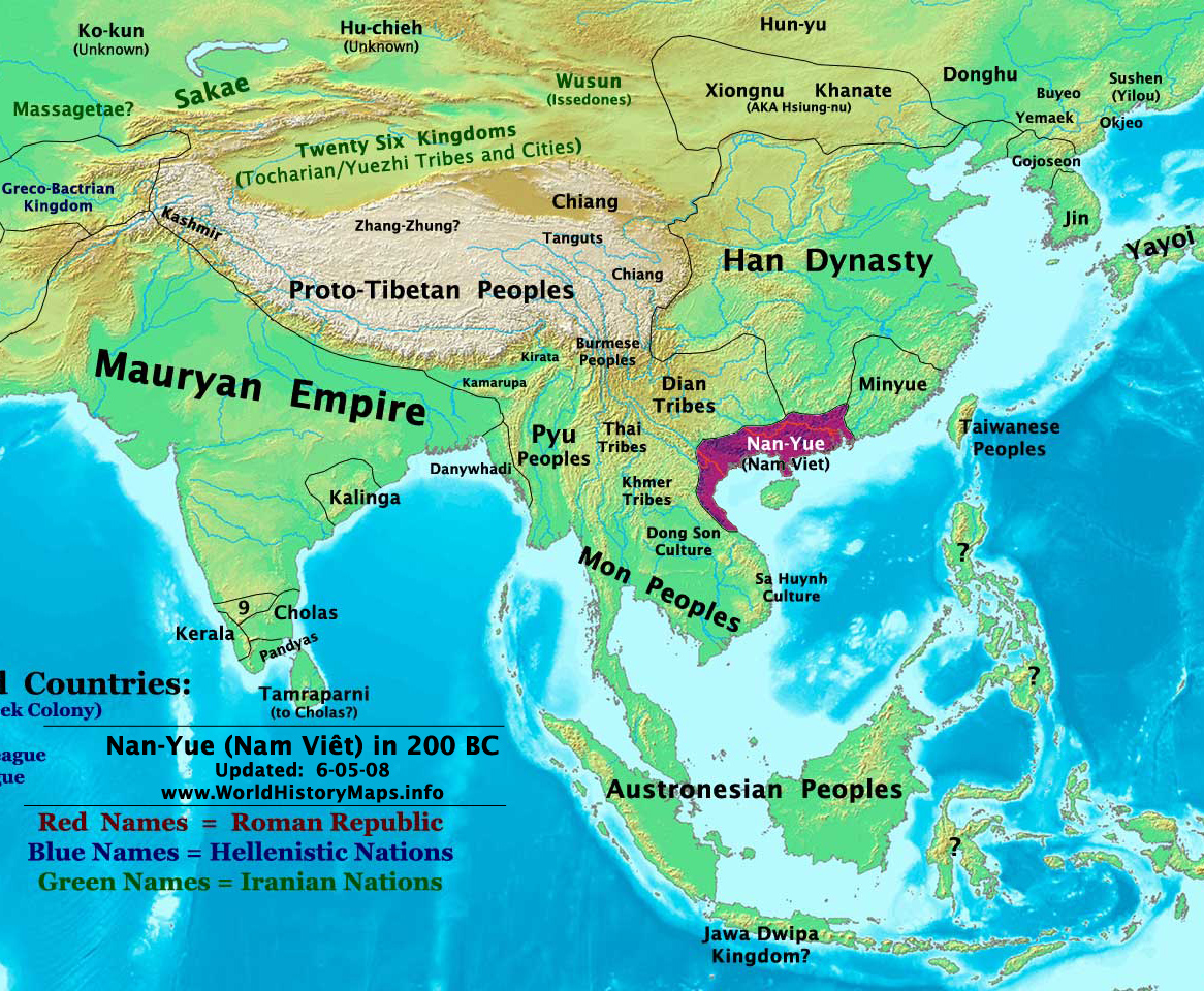
English: Map of ancient Nam Việt (204 BCE - 111 BCE) - an ancient kingdom that consisted of parts of the modern southern Chinese provinces of Guangdong, Guangxi, Yunnan and northern Vietnam.
|
| Petsa | 10 Hulyo 2009 (original upload date) |
| Pinagkunan | Transferred from en.wikipedia to Commons by Alagos. |
| Kagsurat | The original uploader was Sea888 at English Wikipidya. |
Paglisensya
Nakalisensya an file na ini sa irarom kan lisensyang Creative Commons Attribution-Share Alike 3.0 Unported.
- Talingkas mo ining:
- maihiras – makokopya, maipapanao, asin maipapahiling an gibo
- i-remix – ma-adapt an gibo
- Sa irarom kan mga kondisyon na ini:
- atribusyon – Dapat mong i-credit, itao an link kan lisensya, at itukdo kun may binago ini. Pwede mo ining gibuhon sa dawa anong rasonableng paagi, pero bako sa paaging ineendorso ka o an paggamit mo kan naglisensya.
- share alike – Kun ire-remix mo, babaguhon, o madagdag sa materyal, kaipuhan mong ipanao an mga ambag mo sa irarom kan parehas o katulad na lisensya.
Original upload log
The original description page was here. All following user names refer to en.wikipedia.
Upload date | User | Bytes | Dimensions | Comment
- 2009-07-10 19:33:35 | Sea888 | 876342 | 1166×960 | Author: Thomas A. Lessman. Source URL: http://www.worldhistorymaps.info/maps.html. Image was created by me (Thomas Lessman) based on map of Eastern Hemisphere in 200 BC. Image is free for public and/or educational use. I would appreciate a mention if this
Kasaysayan kan file
Pinduton an sarong petsa/oras para mahiling ng file sa puntong idto.
| Petsa/Oras | Thumbnail | Sukol | Paragamit | Komento | |
|---|---|---|---|---|---|
| presente | 15:27, 5 Enero 2013 | | 1,166 × 960 (856 KB) | Alagos | {{CH2MoveToCommons|en.wikipedia|year={{subst:CURRENTYEAR}}|month={{subst:CURRENTMONTHNAME}}|day={{subst:CURRENTDAY}}}} The tool and the bot are operated by User:Jan Luca and User:Magnus Manske. =={{int:filedesc}}== {{Information |description=A... |
Paggamit sa file
Ginagamit kan minasunod na pahina an file na ini:
Pankinaban na paggamit sa file
Ginagamit kan mga minasunod na wiki an file na ini:
- Paggamit sa ast.wikipedia.org
- Paggamit sa bn.wikipedia.org
- Paggamit sa en.wikipedia.org
- Paggamit sa es.wikipedia.org
- Paggamit sa eu.wikipedia.org
- Paggamit sa fi.wikipedia.org
- Paggamit sa fr.wikipedia.org
- Paggamit sa id.wikipedia.org
- Paggamit sa ja.wikipedia.org
- Paggamit sa pnb.wikipedia.org
- Paggamit sa pt.wikipedia.org
- Paggamit sa ru.wikipedia.org
- Paggamit sa th.wikipedia.org
- Paggamit sa uk.wikipedia.org
- Paggamit sa ur.wikipedia.org
- Paggamit sa vi.wikipedia.org