Ladawan:Krakatoa vegetation map 1992-fr.svg

Size of this PNG preview of this SVG file: 600 × 600 na pixel. Ibang mga resolusyon: 240 × 240 na pixel | 480 × 480 na pixel | 768 × 768 na pixel | 1,024 × 1,024 na pixel | 2,048 × 2,048 na pixel | 1,200 × 1,200 na pixel.
Orihinal na file (SVG na file, nominal na 1,200 × 1,200 (na) pixel, pakadakula: 112 KB)
Sumaryo
| Pagladawan |
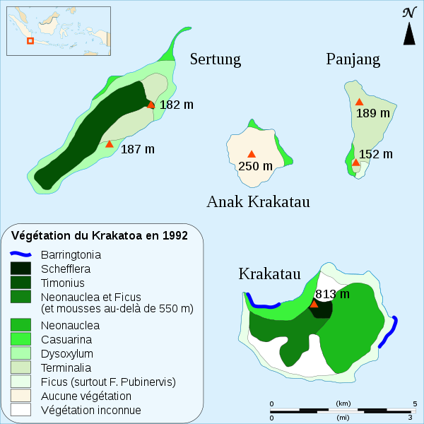
English: Biogeographical map in French of the vegetation in the Krakatoa's archipelago (Indonesia) in 1992.
Français : Carte de répartition de la végétation de l'archipel du Krakatoa (Indonésie) en 1992. |
||
| Petsa | |||
| Pinagkunan |
travail personnel. Sources :
|
||
| Kagsurat | Sémhur | ||
| Other versions | |||
| Atribusyon (required by the license) | © Sémhur / Wikimedia Commons / | ||
| SVG | W3C-validity not checked.
|
||
| Graphic Lab |

| Camera location | | View this and other nearby images on: OpenStreetMap |
|---|
Paglisensya
I, the copyright holder of this work, hereby publish it under the following licenses:
| Copyleft: This work of art is free; you can redistribute it and/or modify it according to terms of the Free Art License. You will find a specimen of this license on the Copyleft Attitude site as well as on other sites. |
This file is licensed under the Creative Commons Attribution-Share Alike 4.0 International, 3.0 Unported, 2.5 Generic, 2.0 Generic and 1.0 Generic license.
- Talingkas mo ining:
- maihiras – makokopya, maipapanao, asin maipapahiling an gibo
- i-remix – ma-adapt an gibo
- Sa irarom kan mga kondisyon na ini:
- atribusyon – Dapat mong i-credit, itao an link kan lisensya, at itukdo kun may binago ini. Pwede mo ining gibuhon sa dawa anong rasonableng paagi, pero bako sa paaging ineendorso ka o an paggamit mo kan naglisensya.
- share alike – Kun ire-remix mo, babaguhon, o madagdag sa materyal, kaipuhan mong ipanao an mga ambag mo sa irarom kan parehas o katulad na lisensya.
Pwede kang makapili nin lisensya mo.
Kasaysayan kan file
Pinduton an sarong petsa/oras para mahiling ng file sa puntong idto.
| Petsa/Oras | Thumbnail | Sukol | Paragamit | Komento | |
|---|---|---|---|---|---|
| presente | 16:00, 22 Abril 2008 | | 1,200 × 1,200 (112 KB) | Sémhur | Ajout d'un espace entre les altitudes et le "m" de mètres |
| 18:50, 20 Abril 2008 |  | 1,200 × 1,200 (113 KB) | Sémhur | {{Information |Description= {{en|Biogeographical map in French of the vegetation in the Krakatoa's archipelago (Indonesia) in 1992.}} {{fr|Carte de répartition de la végétation de l'archipel du Krakatoa (Indonésie) en |
Paggamit sa file
Ginagamit kan minasunod na pahina an file na ini:
Pankinaban na paggamit sa file
Ginagamit kan mga minasunod na wiki an file na ini:
- Paggamit sa ca.wikipedia.org
- Paggamit sa cs.wikipedia.org
- Paggamit sa de.wikipedia.org
- Paggamit sa en.wikipedia.org
- Paggamit sa fr.wikipedia.org
- Paggamit sa fr.wiktionary.org
- Paggamit sa mk.wikipedia.org
- Paggamit sa uk.wikipedia.org
- Paggamit sa uz.wikipedia.org