Ladawan:Omais 2004 track.png

Pakadakula kan pasirip na ini: 800 × 495 na pixel. Ibang mga resolusyon: 320 × 198 na pixel | 640 × 396 na pixel | 1,024 × 633 na pixel | 1,280 × 791 na pixel | 2,700 × 1,669 na pixel.
Orihinal na file (2,700 × 1,669 na pixel, pakadakula: 585 KB, tipo nin MIME: image/png)
| Pagladawan |
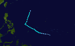
English: Tropical Storm Omais (2004) track. Uses the color scheme from the Saffir-Simpson Hurricane Scale. |
||||||||||||||
| Pinagkunan | Created using Wikipedia:WikiProject Tropical cyclones/Tracks. The background image is from NASA [1]. Tracking data from the Joint Typhoon Warning Center.[2] | ||||||||||||||
| Kagsurat | See file upload history for details. | ||||||||||||||
| I, the copyright holder of this work, release this work into the public domain. This applies worldwide. In some countries this may not be legally possible; if so: I grant anyone the right to use this work for any purpose, without any conditions, unless such conditions are required by law. |
Kasaysayan kan file
Pinduton an sarong petsa/oras para mahiling ng file sa puntong idto.
| Petsa/Oras | Thumbnail | Sukol | Paragamit | Komento | |
|---|---|---|---|---|---|
| presente | 22:21, 1 Nobyembre 2020 | | 2,700 × 1,669 (585 KB) | Supportstorm | 2700 px |
| 19:46, 30 Hulyo 2006 |  | 1,024 × 633 (147 KB) | Nilfanion | {{hurricane auto track map|type=Tropical Storm|name=Omais (2004)|source=JTWC}} |
Paggamit sa file
Ginagamit kan minasunod na pahina an file na ini:
Pankinaban na paggamit sa file
Ginagamit kan mga minasunod na wiki an file na ini:
- Paggamit sa en.wikipedia.org
- Paggamit sa ja.wikipedia.org
- Paggamit sa ko.wikipedia.org
- Paggamit sa pt.wikipedia.org
- Paggamit sa th.wikipedia.org
- Paggamit sa vi.wikipedia.org
- Paggamit sa zh.wikipedia.org