Ladawan:Malay language Spoken Area Map v1.png
Mayo na nin mas malinaw.
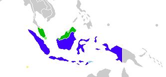
Malay_language_Spoken_Area_Map_v1.png (333 × 154 na pixel, pakadakula: 4 KB, tipo nin MIME: image/png)
Sumaryo

|
This linguistic map image could be re-created using vector graphics as an SVG file. This has several advantages; see Commons:Media for cleanup for more information. If an SVG form of this image is available, please upload it and afterwards replace this template with
{{vector version available|new image name}}.
It is recommended to name the SVG file “Malay language Spoken Area Map v1.svg”—then the template Vector version available (or Vva) does not need the new image name parameter. |
| Pagladawan |
English: This is crop and edit of a .png export of the image at File:BlankMap-World6.svg. The original author released that image into the public domain for any use. This version is released under the CC-Zero license. |
| Petsa | 13 Pebrero 2011 (original upload date) |
| Pinagkunan | Transferred from en.wikipedia to Commons by Zscout370 using CommonsHelper. |
| Kagsurat | True at English Wikipidya |
Paglisensya
True at English Wikipidya, the copyright holder of this work, hereby publishes it under the following license:
| This file is made available under the Creative Commons CC0 1.0 Universal Public Domain Dedication. | |
| The person who associated a work with this deed has dedicated the work to the public domain by waiving all of their rights to the work worldwide under copyright law, including all related and neighboring rights, to the extent allowed by law. You can copy, modify, distribute and perform the work, even for commercial purposes, all without asking permission.
|
Original upload log
The original description page was here. All following user names refer to en.wikipedia.
- 2012-02-20 03:34 Kwamikagami 333×154× (4555 bytes) correct area in Thailand, add Cocos Isl.
- 2012-02-20 03:17 Kwamikagami 333×154× (4570 bytes) Reverted to version as of 23:23, 13 February 2011
- 2011-09-14 23:58 Niduzzi 736×386× (33038 bytes)
- 2011-02-13 23:23 True 333×154× (4570 bytes) This is crop and edit of a .png export of the image at http://en.wikipedia.org/wiki/File:BlankMap-World6.svg. The original author released that image into the public domain for any use. This version is released under the CC-Zero license.
Kasaysayan kan file
Pinduton an sarong petsa/oras para mahiling ng file sa puntong idto.
| Petsa/Oras | Thumbnail | Sukol | Paragamit | Komento | |
|---|---|---|---|---|---|
| presente | 08:23, 25 Pebrero 2022 | | 333 × 154 (4 KB) | Kwamikagami | no longer a map of where Malay is spoken |
| 05:52, 26 Oktubre 2018 |  | 4,387 × 1,922 (336 KB) | Bennylin | Edit some colors | |
| 05:40, 26 Oktubre 2018 |  | 4,300 × 1,918 (535 KB) | Bennylin | Change ugly map with PNG version of File:Maritime South East Asia.svg | |
| 04:51, 21 Hunyo 2012 |  | 333 × 154 (4 KB) | File Upload Bot (Magnus Manske) | Transfered from en.wikipedia by User:zscout370 using CommonsHelper |
Paggamit sa file
Mayong pahinang naggagamit sa file na ini.
Pankinaban na paggamit sa file
Ginagamit kan mga minasunod na wiki an file na ini:
- Paggamit sa ckb.wikipedia.org
- Paggamit sa el.wikipedia.org
- Paggamit sa en.wikipedia.org
- Paggamit sa es.wikipedia.org
- Paggamit sa fa.wikipedia.org
- Paggamit sa frr.wikipedia.org
- Paggamit sa id.wikipedia.org
- Paggamit sa incubator.wikimedia.org
- Paggamit sa mi.wikipedia.org
- Paggamit sa nl.wikipedia.org
- Paggamit sa zh.wikipedia.org