Ladawan:Luzon Strait n7184.jpg

Pakadakula kan pasirip na ini: 318 × 598 na pixel. Ibang mga resolusyon: 127 × 240 na pixel | 542 × 1,020 na pixel.
Orihinal na file (542 × 1,020 na pixel, pakadakula: 77 KB, tipo nin MIME: image/jpeg)
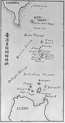
| Pagladawan | Old map of the Luzon Strait (not labeled), including the Bashi Channel, between Orchid Island (Botel Tobago on the map) of Taiwan and the Batan Islands of the Philippines. Names may be out of date. Japanese caption: "Islands between Taiwan and Luzon". | |||||
| Petsa | Daí aram an petsa | |||||
| Pinagkunan |
From digital archive of the University of Tokyo. [1] Cropped by a-giâu. |
|||||
| Kagsurat | anthropologist Torii Ryūzō (1870-1953) | |||||
| Pagtugot (Giraray na paggamit sa file) |
|


Kasaysayan kan file
Pinduton an sarong petsa/oras para mahiling ng file sa puntong idto.
| Petsa/Oras | Thumbnail | Sukol | Paragamit | Komento | |
|---|---|---|---|---|---|
| presente | 23:30, 11 Nobyembre 2004 | | 542 × 1,020 (77 KB) | A-giâu | Old map of the Luzon Strait,(not labeled), including the Bashi Channel, between Orchid Island (Botel Tobago in the map) of Taiwan and the Batanes of the Philippines. Names may be out of date. From digital archive of the Universit |
Paggamit sa file
Ginagamit kan minasunod na pahina an file na ini:
Pankinaban na paggamit sa file
Ginagamit kan mga minasunod na wiki an file na ini:
- Paggamit sa ar.wikipedia.org
- Paggamit sa ast.wikipedia.org
- Paggamit sa az.wikipedia.org
- Paggamit sa be.wikipedia.org
- Paggamit sa ca.wikipedia.org
- Paggamit sa ceb.wikipedia.org
- Paggamit sa cs.wikipedia.org
- Paggamit sa da.wikipedia.org
- Paggamit sa de.wikipedia.org
- Paggamit sa en.wikipedia.org
- Paggamit sa es.wikipedia.org
- Paggamit sa eu.wikipedia.org
- Paggamit sa fa.wikipedia.org
- Paggamit sa fr.wikipedia.org
- Paggamit sa he.wikipedia.org
- Paggamit sa hi.wikipedia.org
- Paggamit sa id.wikipedia.org
- Paggamit sa ilo.wikipedia.org
- Paggamit sa it.wikipedia.org
- Paggamit sa ja.wikipedia.org
- Paggamit sa ko.wikipedia.org
- Paggamit sa lt.wikipedia.org
- Paggamit sa mk.wikipedia.org
- Paggamit sa nl.wikipedia.org
- Paggamit sa no.wikipedia.org
Hilingon an kadagdagan na pankinaban na paggamit sa file na ini.