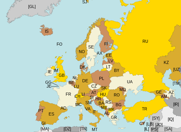
Ladawan:Europe ISO 3166-1.svg

Size of this PNG preview of this SVG file: 700 × 512 na pixel. Ibang mga resolusyon: 320 × 234 na pixel | 640 × 468 na pixel | 1,024 × 749 na pixel | 1,280 × 936 na pixel | 2,560 × 1,872 na pixel.
Orihinal na file (SVG na file, nominal na 700 × 512 (na) pixel, pakadakula: 384 KB)
Kasaysayan kan file
Pinduton an sarong petsa/oras para mahiling ng file sa puntong idto.
| Petsa/Oras | Thumbnail | Sukol | Paragamit | Komento | |
|---|---|---|---|---|---|
| presente | 22:43, 10 Agosto 2015 |  | 700 × 512 (384 KB) | SiBr4 | Increasing contrast by slightly changing the map colors; splitting Serbia and Montenegro; cropping some more; plain SVG |
| 18:46, 10 Abril 2012 |  | 800 × 512 (421 KB) | Ras67 | "cropped" | |
| 04:52, 13 Marso 2011 |  | 800 × 520 (597 KB) | Chipmunkdavis | Fixing Turkey, adding Gibraltar | |
| 23:11, 22 Agosto 2009 |  | 800 × 520 (599 KB) | Tintazul | Croatia, Palestine | |
| 23:15, 4 Nobyembre 2007 |  | 800 × 520 (601 KB) | Lupo | Re-upload; trying to fix wrong MIME type | |
| 13:06, 14 Agosto 2007 | Mayong thumbnail | (601 KB) | Tintazul | replaced CS with RS+ME; replaced UK with GB; added AX, SJ, FO, IM, GG, JE | |
| 01:32, 11 Enero 2007 |  | 800 × 520 (594 KB) | Angus | PT → HR | |
| 21:51, 7 Hunyo 2006 |  | 800 × 520 (594 KB) | Tintazul | {{Tintazul| |Description=Map of Europe, with ISO 3166-1 <sup>pt · en</sup> country and territory codes. SVG format. Map legend in Portuguese and English, with name of sovereign state given in parenthesis, where appl |
Paggamit sa file
Ginagamit kan minasunod na pahina an file na ini:
Pankinaban na paggamit sa file
Ginagamit kan mga minasunod na wiki an file na ini:
- Paggamit sa ar.wikipedia.org
- Paggamit sa arz.wikipedia.org
- Paggamit sa bg.wikipedia.org
- Paggamit sa bn.wikipedia.org
- Paggamit sa ca.wikipedia.org
- Paggamit sa cs.wikipedia.org
- Paggamit sa en.wikipedia.org
- Paggamit sa eo.wikipedia.org
- Paggamit sa es.wikipedia.org
- Paggamit sa fi.wikipedia.org
- Paggamit sa fo.wikipedia.org
- Paggamit sa fr.wikipedia.org
- Paggamit sa gl.wikipedia.org
- Paggamit sa he.wikipedia.org
- Paggamit sa hy.wikipedia.org
- Paggamit sa id.wikipedia.org
- Paggamit sa ilo.wikipedia.org
- Paggamit sa ja.wikipedia.org
- Paggamit sa ka.wikipedia.org
- Paggamit sa lt.wikipedia.org
- Paggamit sa mk.wikipedia.org
- Paggamit sa nl.wikipedia.org
- Paggamit sa no.wikipedia.org
- Paggamit sa pt.wikipedia.org
- Paggamit sa ru.wikipedia.org
- Paggamit sa rw.wikipedia.org
- Paggamit sa si.wikipedia.org
- Paggamit sa sr.wikipedia.org
- Paggamit sa su.wikipedia.org
- Paggamit sa ta.wikipedia.org
- Paggamit sa www.wikidata.org
- Paggamit sa zh.wikipedia.org