Ladawan:Bosnia and Hercegovina map.png

Orihinal na file (2,302 × 2,901 na pixel, pakadakula: 1.5 MB, tipo nin MIME: image/png)
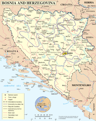
UN Bosnia and Hercegovina map
| Pagladawan | Map of Bosnia and Hercegovina | |||
| Petsa | ||||
| Pinagkunan | The Cartographic Section of the United Nations (CSUN) | |||
| Kagsurat | Cartographer of the United Nations | |||
| Pagtugot (Giraray na paggamit sa file) |
|

Kasaysayan kan file
Pinduton an sarong petsa/oras para mahiling ng file sa puntong idto.
| Petsa/Oras | Thumbnail | Sukol | Paragamit | Komento | |
|---|---|---|---|---|---|
| presente | 16:48, 11 Mayo 2010 | | 2,302 × 2,901 (1.5 MB) | Ras67 | cropped |
| 01:26, 23 Oktubre 2007 |  | 2,348 × 2,948 (2.05 MB) | Jeroen | Higher reolution | |
| 23:03, 9 Marso 2007 |  | 1,880 × 2,349 (1.28 MB) | Minestrone | UN Bosnia and Hercegovina map {{Information |Description=Map of Bosnia and Hercegovina |Source=The Cartographic Section of the United Nations (CSUN) |Date=2007-03-10 |Author=Cartographer of the United Nations |Permission={{Template:UN map}} and the |
Paggamit sa file
Ginagamit kan minasunod na pahina an file na ini:
Pankinaban na paggamit sa file
Ginagamit kan mga minasunod na wiki an file na ini:
- Paggamit sa ace.wikipedia.org
- Paggamit sa als.wikipedia.org
- Paggamit sa an.wikipedia.org
- Paggamit sa ckb.wikipedia.org
- Paggamit sa cu.wikipedia.org
- Paggamit sa de.wikipedia.org
- Paggamit sa en.wikipedia.org
- Paggamit sa fa.wikipedia.org
- Paggamit sa frr.wikipedia.org
- Paggamit sa gd.wikipedia.org
- Paggamit sa hy.wikipedia.org
- Paggamit sa id.wikipedia.org
- Paggamit sa incubator.wikimedia.org
- Paggamit sa ja.wikipedia.org
- Paggamit sa jv.wikipedia.org
- Paggamit sa kg.wikipedia.org
- Paggamit sa ki.wikipedia.org
- Paggamit sa ln.wikipedia.org
- Paggamit sa my.wikipedia.org
- Paggamit sa mzn.wikipedia.org
- Paggamit sa nl.wikipedia.org
- Paggamit sa nov.wikipedia.org
- Paggamit sa pl.wiktionary.org
- Paggamit sa ru.wikipedia.org
- Paggamit sa sl.wikipedia.org
- Paggamit sa sq.wikinews.org
- Paggamit sa uk.wikipedia.org
- Paggamit sa uk.wiktionary.org
- Paggamit sa wo.wikipedia.org