Hillsboro, Missouri
An Hillsboro sarong siyudad sa Jefferson County, Missouri, Estados Unidos. An populasyon kaini 3,473 sa 2020 senso, na mas naglangkaw sa dati kaining 2,821 kan 2010. An Hillsboro iyo tukawang nin county kan Jefferson County.[5]
Hillsboro, Missouri | |
|---|---|
 Jefferson County Courthouse in Hillsboro | |
| Mga palayaw: The Boro | |
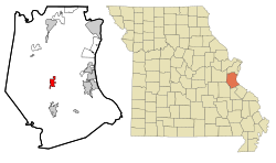
 Location of Hillsboro, Missouri | |
| Tagboan: 38°13′59″N 90°34′02″W / 38.23306°N 90.56722°WTagboan: 38°13′59″N 90°34′02″W / 38.23306°N 90.56722°W | |
| Country | United States |
| State | Missouri |
| County | Jefferson |
| Incorporated | 1839 |
| Pamamahala | |
| • Mayor | Buddy Russell[1] |
| Hiwas | |
| • Kabuuhan | 9.95 km2 (3.84 sq mi) |
| • Kadagáan | 9.95 km2 (3.84 sq mi) |
| • Katubigan | 0.00 km2 (0.00 sq mi) |
| Elebasyon | 235 m (771 ft) |
| Populasyon (2020) | |
| • kabuuhan | 3,473 |
| • Densidad | 348.98/km2 (903.96/sq mi) |
| Sona nin oras | UTC-6 (Central (CST)) |
| • Tig-init (DST) | UTC-5 (CDT) |
| ZIP code | 63050 |
| Area code(s) | 636 |
| FIPS code | 29-32248[4] |
| GNIS feature ID | 2394388[3] |
| Websityo | hillsboromo.org |
Historya
baguhonAn Hillsboro dati an apod Monticello, awin nkinamundagan ni Presidente Thomas Jefferson.[6] An pangaran na Monticello rinibayan ta an E.U. na autoridad postal habong akoon ining pangaaran ta may dati nang pangaran sa laog kan estado na parehas man. An pagaran kaining presente na Hillsboro katumbas na Ingles kan Italyanong Montecillo.[7] A post office has been in operation at Hillsboro since 1838.[8]
An Thomas C. Fletcher House asin Sandy Creek Covered Bridge nakalista sa National Register of Historic Places.[9]
Geograpiya
baguhonSusog sa United States Census Bureau, an siyudad igwa kahiwasan na 3.65 square miles (9.45 km2), anas kadagaan.[10]
Demograpiko
baguhonToltolan
baguhon- ↑ City of Hillsboro.
- ↑ "ArcGIS REST Services Directory". United States Census Bureau. Retrieved August 28, 2022.
- ↑ 3.0 3.1 U.S. Geological Survey Geographic Names Information System: Hillsboro, Missouri
- ↑ "U.S. Census website". United States Census Bureau. Retrieved 2008-01-31.
- ↑ "Find a County". National Association of Counties. Archived from the original on May 31, 2011. Retrieved 2011-06-07. Unknown parameter
|url-status=ignored (help) - ↑ "Jefferson County Place Names, 1928–1945 (archived)". The State Historical Society of Missouri. Archived from the original on 24 June 2016. Retrieved 19 October 2016. Unknown parameter
|url-status=ignored (help) - ↑ "Disappearing Missouri Names". The Kansas City Star: p. 15. March 19, 1911. https://www.newspapers.com/clip/861825/missouri_toponyms/. Plantilya:Open access
- ↑ "Post Offices". Jim Forte Postal History. Retrieved 19 October 2016.
- ↑ Plantilya:NRISref
- ↑ "US Gazetteer files 2010". United States Census Bureau. Archived from the original on January 12, 2012. Retrieved 2012-07-08. Unknown parameter
|url-status=ignored (help)